
Monday, October 16, 2006
Für die Statistik:
Am Mittwoch, dem 30. August bin ich abends in Montreal angekommen, am Sonnabend, dem 23. September haben mich David und seine Mutter nachmittags zum Flughafen gebracht. Das sind 23,5 Tage in Nordamerika.
Am Anfang habe ich 2 Tage in Montreal verbracht, in Jamaica habe ich mich einen Tag aus Sorge um mein Knie ausgeruht, in Boston habe ich 2 Tage bei und mit Tanya verbracht, und für die große Stadt New York hatte ich 3,5 Tage Zeit. Das sind 8,5 Tage ohne Fahrradfahrt. Anders ausgedrückt, gab es auf der Reise nur 15 Fahrtage.
Der Kilometerzähler verzeichnet 1136 km als Wegstrecke. Bei 15 Fahrtagen ergeben sich somit durchschnittlich 75,73 km pro Tag.
---
I cycled only on 15 days out of the total of 23,5 days in North America. The recorded overall distance was 1136 km. Thus, on average I cycled 75,73 km per day.
Tuesday, October 10, 2006
Cycling from Boston to New York. A Long Letter
Dear Tanya,
after we parted in Hingham on Friday (9/15/2006), I cycled all along the cost line towards Plymouth. Again, Rubel's BikeMap was of great help, and the ride was very enjoyable until the rain set in. Earlier, you said wisely that there is no point in being disappointed or unhappy about rain because it would come anyway. Rain would be just one of the many things in life that cannot be avoided, so one should not get angry or sad or unhappy about it. Well, I tried to follow your advice.
When I reached Plymouth, I was quite wet, and it was already 5:30 PM. So I asked the in the local bicycle shop whether there would be a cheap motel or some other place suitable for cyclists in or near Plymouth. The man - about 50 years old, tall, not quite slim, a bit of a bald spot, a monks face, if you want, and very authoritative in his appearance - answered: "Welcome to the centre of the universe. You are right here. I'd recommend the Best Western Motor Inn, just a bit further down the road. You can't miss it. No campsites here. You are in Plymouth, don't forget that."
A night in the Best Western Motor Inn would have cost me $135. I arrived at the Tourist Information just after 6 PM. The people working there were just about to leave and to close for the day, but the somewhat older man in charge of things was kind enough to let me in and to recommend another motel and a B&B to me - but both were over $70. Then it turned out that there would be 2 campsites in the surroundings of Plymouth, or at least that's what I understood. Sandy Pond Campground was the cheaper of the two ($28), and I understood that it would be just 6 miles away. Very happy about this solution, I said "No problem, 6 miles is no problem at all," thanked the good man for his kind help and set off.
Plymouth Rock was no photo opportunity at all, it was still very grey, the time about 6:30, and rain in the air. The town itself struck me as a provincial fishermen's town with highbrow aspirations. (This very evening, an arts festival was to begin. I passed by the tents where the opening reception was to be hold.) But alas, Plymouth was bigger than expected, and when I finally left the last houses behind, it was already sevenish. In other words, it got darker and darker. Looking at the map and comparing it with the road names on the advertising flyer for the campground, I found out that there was still a very long way to go. Hence, I had to prepare myself for cycling in the dark - the first time ever on this journey. Now, cycling in the dark is not really comforting when you are not sure of your way. With every bend you hope that you are there, and you envy the people in the houses you pass by. Most importantly, you fear missing the one intersection where you have to turn right and then again the next one where you have to turn left. In the end, even according to the map, it was 12 miles to Sandy Pond Campground, so I cycled on for at least 21 km, cursing and swearing at times because I had no clear idea of how far I had gone already in relation to my destination. I arrived in the complete dark, after 8 pm.
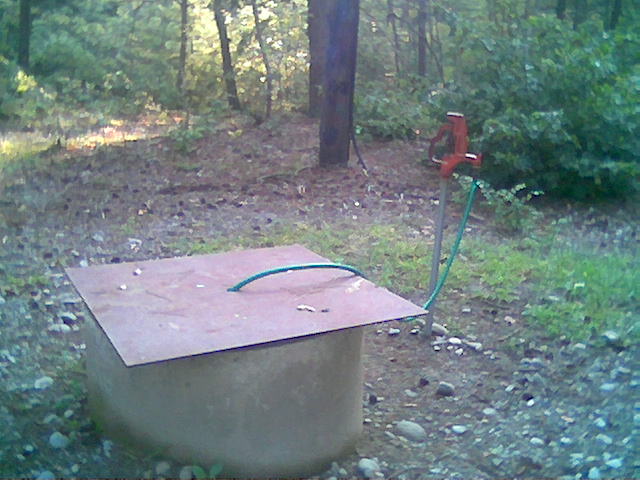
On Saturday (9/16/2006) I came as far as Rehobooth, a village in the west of Providence. It was hot sunny day, cycling was on the whole very beautiful and enjoyable, but I have to admit that I did not see much of the wide open country. There were stretches of real beauty, but for the most part, the land is relatively thickly settled. I had a really good coffee and an even better muffin in Onset - it was the kind of seaside resort experience you would not want to miss: sun in abundance, friendly staff and above all the delicious taste of coffee in your mouth. A cycling day without a good morning coffee can still be a good day, but it's so much better if the day starts with a decent double shot espresso (ideally served in a real cup - but that's too much to ask in America). I went on via Wareham and Rochester, East Freetown to Rehobooth. Again, I did not know where to spend the night. I asked a very friendly couple next to the central church and was advised that there would be a place where the scouts hold their camps. I checked this out and found that Water (a real necessity after this hot day) was coming off the one tap. So I asked a neighbour (apparently a school bus driver) whether he knew who was responsible. He didn't know but said I would be OK if no one was there. So I committed my first illegal act in the US: I trespassed. The night was not too bad, and I got up early the next morning. Much to my surprise, there was no water coming from the tap anymore - a real water miracle: Water was there when I needed it most, but just once. I thanked God for his mercy, took a photo of this mysterious tap ...
... and left for Providence.
Arriving in Providence midmorning, I found the hill where Brown University is located most appealing and went there first. It was shortly after 10:30, and I was definitely in the mood to attend Sunday service. The church just ahead looked promising, the usher wore shorts and a jacket, and on asking whether I'd be allowed in with cycling shorts and T-shirt, he said "of course" (in fact, I had been rejected earlier in this apparel in the village church of Jamaica). It turned out that I had come to a meetinghouse of the Unitarian Universalists, a group that would not mention god or Jesus explicitly during the whole service.
Getting out of Providence was not quite easy. There is a really beautiful bike path, but I had no decent map showing where it would lead to. Someone cycling on it said "Warwick", which was not quite where I wanted to go. So tried to find my way along the hot Sunday streets for quite some time. A young employee at a gas station (himself a cyclist) finally told me that the bike path leads in fact to West Warwick and Coventry, which was exactly where I wanted to go. He gave me the directions accordingly, and I greatly enjoyed cycling on this smooth and elegant bike path built on a disused railway line (click here for maps).
As I just indicated, I had no decent map anymore. When I came into Providence, I left the territory covered by my Rubel BikeMap of Southeastern Massachusetts, and I had no other bike map. The only maps I had were the two road maps that I bought in Germany. Leaving Coventry, I wanted to go to "West Greenwich Center" (a point with an intersection on my map) and then head south. But of course, I needed to find the right road first. So I asked people in Coventry. They just understood "West Greenwich" and directed me to state road 3, which is a four-lane road more or less parallel to Interstate 95. Unfortunately, this road seemed not to be on my maps - at least there is no road marked "number 3", and the road that I suspected to be the one I was cycling on was not depicted as a four-lane road. Even worse, there was a road sign saying "West Greenwich", but there was only a fire station, hardly any other houses and no sign whatsoever for the centre of this village. So, where was the real West Greenwich? I was utterly lost and confused. It was getting towards 5 o'clock, and I was running out of water. The next thing I saw (after the intersection with road 102) was a farm stand. I asked for water, wanted to know where I was and also thought it might be well worth asking for a campground because the time was about right. I had already cycled nearly 70 km that day. In reply to my questions, I was told that I was "in Exeter" (which on my map is quite a bit off the road resembling road 3 ) and that there would be "Alton Jones Campground" ("not a proper campground, but you can camp there"). To get there, I would have to go back a little and to turn left "at the second light". So I did - but unfortunately, I took the second light as belonging to the first because it was in principle the same intersection. On the so-called "first" traffic light the 102 left off to the right, and on the second to the left - the intersection did not exactly constitute a cross. I missed this turn and went on for I don't know how many kilometres until I reached another farm stand. It was quite hilly, the sort of long hills you really get to hate: not too steep, but steep enough to make you suffer over time.... - To cut the story short, I had to go back to the 102 intersection and then turn right to get to "Alton Jones Camp-" slight hesitation - "campground". I got there, and the sign said: "University of Rhode Island, W. Alton Jones Campus". I had severe doubts that I could indeed pitch up my tent there. But then again, I was caught in a mixture of curiosity and trust to those people at the farm stands. I decided to have a look and go 3 or more km up the hill and down the hill to the actual campus. I even found a populated house, and on calling "hello" several times, a young lady preparing some food came out with this kind of "Can I help you?" that indicates that you've just disturbed someone. Of course I could not stay at Alton Jones Campus. I was advised to go to Arcadia, not very far from here ("we are neighbouring it"). "When I reach the main road, do I have to turn left to get to Arcadia?" - The answer was in the affirmative, but somewhat insecure.
So, onwards, the effort will not be to great, Arcadia is supposed to be not too far. Riding for a while along the 102 northbound without seeing Arcadia, my doubts grew. I saw 2 men and woman sitting at a camping desk next to their house under a tree, a really nice family setting. I decided to ask again how far Arcadia would be. Well, I was to hear that I was completely wrong and that I had to go back all the way to road 3, turn right (south-westbound) until I reach the intersection with road 165 (after a pizzeria) and then turn right again. I couldn't believe my ears. It was clearly after 6 PM by then, I had been going around in circles for quite some time, and the end of the day was not even in sight. I was really angry with those wicked messengers (listen to the Bob Dylan song of that title), but of course, they were not to blame for telling the truth. I stopped short of asking them whether I could camp in their garden, but I went as far as to say that I really need some place to stay for the night and that I would be willing to pay, hoping that with a bit of business instinct they would smell the chance of an easy extra $20. It didn't work, they told me that there would be a truckers' motel on the way.
I finally reached Arcadia, I even saw a rather impressive sunset on the way, but it was not at all clear whether and more importantly WHERE I could camp. Arcadia State Managed Area has several entries to the left and the right of road 165 (maps are here). Again, I asked everybody I could get hold off. I accidentally disturbed a couple breast-feeding their baby ("We are breast-feeding!!!," yelled the husband when I addressed him somewhat too loudly and too quickly through the open window of his SUV. The horror and anger in his voice is now part of my subconscious). Finally I found a wood gnome type of person with the air of someone not too intelligent, carrying a couple of mushrooms to his pick up truck. This man was really kind and helpful and knew to tell the birds from their song. He also knew that there was official campground not too far off ("up the next hill and down again, and where the road bends to the left, you get to an intersection where you have to turn right, and then it's another 2 miles..."). My thin man of the woods even waited at the intersection just to make sure that I don't miss it. Still, it was spooky to cycle along a narrow hilly road in the absolute dark, not really knowing where the entrance of the campground would be. I feared missing it. I even asked at a rather posh-looking house whether I was still on the right track (yes, I was - grudging as the response was). In the end, the campground was brightly lit, and I met the Dude (a hippyish guy in his 50ies who helped me to find the people who run the place - he seemed pretty much to be at home at this campground...). On that day, I had cycled 100 km - and at least 25 of them were absolutely for nothing.
The horrors of Sunday gone, I found the road just sweet on Monday (9/18/2006). I headed towards Voluntown on route 165, then left towards Glasgo, Old Mystic and Groton. In Groton, I had to find the foot & cyclists' access to the bridge over the Connecticut river, and again the most unlikely person on earth knew: someone working or staying in a motel near the bridge, walking on crutches and speaking with a strange and hardly understandable voice - the receptionist in the motel "translated" his words for me.
Reaching New London, I wanted to go straight away to the Long Island ferry, but on asking for the way, I was approached by a strong, broad-shouldered young man who asked me enthusiastically where I came from. Then he absolutely wanted to invite me into the house and even offered some salad: "We've really a lot of salad left from lunch". It turned out that he was a power cyclist himself, having ridden from Oregon to Connecticut in 37 days (average distance per day: 100 miles). The house he in invited me into was his workplace, a day care home for disabled people. We had a nice chat, and the salad was gorgeous.
I caught the 4 PM ferry for Long Island. The steamer left in the brightest sunshine, and I would have wanted to re-read Crossing Brooklyn Ferry because I thought I'd be already very close to New York City. But Long Island is not a small island at all, and I was very happy to hear that there was a campground as close as Greenport. I stayed there for the night and sweetened the evening in this seaside resort with a good ice cream. But even more enjoyable was the little chat on the porch with the Italian owner of Flavors Ice Cream and Coffee Shop who - it turned out - had very close family relations to Germany and who recommended Aldo's for a good, strong morning coffee. And indeed, the espresso dopio at Aldo's was a miracle. It came quite naturally in a china cup and was as strong as the late morning sun.
On the way from Greenport to Stony Brook, I tasted Long Island wine (too expensive for the quality, I found), got again confused by the absence of signposts at intersections (poor signposting had often been a cause of mild anger during the journey), developed a pain in my left foot (something with the sinews, I think - the pain stayed throughout the rest of the trip) and finally got very wet in Port Jefferson. On Tuesday, September 19th, 18:49 I took the train from Stony Brook to New York City where I arrived cheered up by the friendliness and cooperativeness of New York conductors and many a talk with strangers who saw the bike and asked questions (one of them beautifully gay, paying me compliments and asking about the situation of gays and lesbians in Germany...). When I left Penn Station, I saw the Empire State Building and Macy's, and I knew immediately that I was THERE.
Now I hope that my poor English hasn't put you off. Indeed, I don't quite dare to post this account on the blog because I just wrote down what happened without much editing. But then again, the blog would probably be the right place for it...
Nochmal Danke für die Zeit in Boston und alles Liebe, wo auch immer Du gerade bist.
Frank
after we parted in Hingham on Friday (9/15/2006), I cycled all along the cost line towards Plymouth. Again, Rubel's BikeMap was of great help, and the ride was very enjoyable until the rain set in. Earlier, you said wisely that there is no point in being disappointed or unhappy about rain because it would come anyway. Rain would be just one of the many things in life that cannot be avoided, so one should not get angry or sad or unhappy about it. Well, I tried to follow your advice.
When I reached Plymouth, I was quite wet, and it was already 5:30 PM. So I asked the in the local bicycle shop whether there would be a cheap motel or some other place suitable for cyclists in or near Plymouth. The man - about 50 years old, tall, not quite slim, a bit of a bald spot, a monks face, if you want, and very authoritative in his appearance - answered: "Welcome to the centre of the universe. You are right here. I'd recommend the Best Western Motor Inn, just a bit further down the road. You can't miss it. No campsites here. You are in Plymouth, don't forget that."
A night in the Best Western Motor Inn would have cost me $135. I arrived at the Tourist Information just after 6 PM. The people working there were just about to leave and to close for the day, but the somewhat older man in charge of things was kind enough to let me in and to recommend another motel and a B&B to me - but both were over $70. Then it turned out that there would be 2 campsites in the surroundings of Plymouth, or at least that's what I understood. Sandy Pond Campground was the cheaper of the two ($28), and I understood that it would be just 6 miles away. Very happy about this solution, I said "No problem, 6 miles is no problem at all," thanked the good man for his kind help and set off.
Plymouth Rock was no photo opportunity at all, it was still very grey, the time about 6:30, and rain in the air. The town itself struck me as a provincial fishermen's town with highbrow aspirations. (This very evening, an arts festival was to begin. I passed by the tents where the opening reception was to be hold.) But alas, Plymouth was bigger than expected, and when I finally left the last houses behind, it was already sevenish. In other words, it got darker and darker. Looking at the map and comparing it with the road names on the advertising flyer for the campground, I found out that there was still a very long way to go. Hence, I had to prepare myself for cycling in the dark - the first time ever on this journey. Now, cycling in the dark is not really comforting when you are not sure of your way. With every bend you hope that you are there, and you envy the people in the houses you pass by. Most importantly, you fear missing the one intersection where you have to turn right and then again the next one where you have to turn left. In the end, even according to the map, it was 12 miles to Sandy Pond Campground, so I cycled on for at least 21 km, cursing and swearing at times because I had no clear idea of how far I had gone already in relation to my destination. I arrived in the complete dark, after 8 pm.
On Saturday (9/16/2006) I came as far as Rehobooth, a village in the west of Providence. It was hot sunny day, cycling was on the whole very beautiful and enjoyable, but I have to admit that I did not see much of the wide open country. There were stretches of real beauty, but for the most part, the land is relatively thickly settled. I had a really good coffee and an even better muffin in Onset - it was the kind of seaside resort experience you would not want to miss: sun in abundance, friendly staff and above all the delicious taste of coffee in your mouth. A cycling day without a good morning coffee can still be a good day, but it's so much better if the day starts with a decent double shot espresso (ideally served in a real cup - but that's too much to ask in America). I went on via Wareham and Rochester, East Freetown to Rehobooth. Again, I did not know where to spend the night. I asked a very friendly couple next to the central church and was advised that there would be a place where the scouts hold their camps. I checked this out and found that Water (a real necessity after this hot day) was coming off the one tap. So I asked a neighbour (apparently a school bus driver) whether he knew who was responsible. He didn't know but said I would be OK if no one was there. So I committed my first illegal act in the US: I trespassed. The night was not too bad, and I got up early the next morning. Much to my surprise, there was no water coming from the tap anymore - a real water miracle: Water was there when I needed it most, but just once. I thanked God for his mercy, took a photo of this mysterious tap ...
... and left for Providence.
Arriving in Providence midmorning, I found the hill where Brown University is located most appealing and went there first. It was shortly after 10:30, and I was definitely in the mood to attend Sunday service. The church just ahead looked promising, the usher wore shorts and a jacket, and on asking whether I'd be allowed in with cycling shorts and T-shirt, he said "of course" (in fact, I had been rejected earlier in this apparel in the village church of Jamaica). It turned out that I had come to a meetinghouse of the Unitarian Universalists, a group that would not mention god or Jesus explicitly during the whole service.
Getting out of Providence was not quite easy. There is a really beautiful bike path, but I had no decent map showing where it would lead to. Someone cycling on it said "Warwick", which was not quite where I wanted to go. So tried to find my way along the hot Sunday streets for quite some time. A young employee at a gas station (himself a cyclist) finally told me that the bike path leads in fact to West Warwick and Coventry, which was exactly where I wanted to go. He gave me the directions accordingly, and I greatly enjoyed cycling on this smooth and elegant bike path built on a disused railway line (click here for maps).
As I just indicated, I had no decent map anymore. When I came into Providence, I left the territory covered by my Rubel BikeMap of Southeastern Massachusetts, and I had no other bike map. The only maps I had were the two road maps that I bought in Germany. Leaving Coventry, I wanted to go to "West Greenwich Center" (a point with an intersection on my map) and then head south. But of course, I needed to find the right road first. So I asked people in Coventry. They just understood "West Greenwich" and directed me to state road 3, which is a four-lane road more or less parallel to Interstate 95. Unfortunately, this road seemed not to be on my maps - at least there is no road marked "number 3", and the road that I suspected to be the one I was cycling on was not depicted as a four-lane road. Even worse, there was a road sign saying "West Greenwich", but there was only a fire station, hardly any other houses and no sign whatsoever for the centre of this village. So, where was the real West Greenwich? I was utterly lost and confused. It was getting towards 5 o'clock, and I was running out of water. The next thing I saw (after the intersection with road 102) was a farm stand. I asked for water, wanted to know where I was and also thought it might be well worth asking for a campground because the time was about right. I had already cycled nearly 70 km that day. In reply to my questions, I was told that I was "in Exeter" (which on my map is quite a bit off the road resembling road 3 ) and that there would be "Alton Jones Campground" ("not a proper campground, but you can camp there"). To get there, I would have to go back a little and to turn left "at the second light". So I did - but unfortunately, I took the second light as belonging to the first because it was in principle the same intersection. On the so-called "first" traffic light the 102 left off to the right, and on the second to the left - the intersection did not exactly constitute a cross. I missed this turn and went on for I don't know how many kilometres until I reached another farm stand. It was quite hilly, the sort of long hills you really get to hate: not too steep, but steep enough to make you suffer over time.... - To cut the story short, I had to go back to the 102 intersection and then turn right to get to "Alton Jones Camp-" slight hesitation - "campground". I got there, and the sign said: "University of Rhode Island, W. Alton Jones Campus". I had severe doubts that I could indeed pitch up my tent there. But then again, I was caught in a mixture of curiosity and trust to those people at the farm stands. I decided to have a look and go 3 or more km up the hill and down the hill to the actual campus. I even found a populated house, and on calling "hello" several times, a young lady preparing some food came out with this kind of "Can I help you?" that indicates that you've just disturbed someone. Of course I could not stay at Alton Jones Campus. I was advised to go to Arcadia, not very far from here ("we are neighbouring it"). "When I reach the main road, do I have to turn left to get to Arcadia?" - The answer was in the affirmative, but somewhat insecure.
So, onwards, the effort will not be to great, Arcadia is supposed to be not too far. Riding for a while along the 102 northbound without seeing Arcadia, my doubts grew. I saw 2 men and woman sitting at a camping desk next to their house under a tree, a really nice family setting. I decided to ask again how far Arcadia would be. Well, I was to hear that I was completely wrong and that I had to go back all the way to road 3, turn right (south-westbound) until I reach the intersection with road 165 (after a pizzeria) and then turn right again. I couldn't believe my ears. It was clearly after 6 PM by then, I had been going around in circles for quite some time, and the end of the day was not even in sight. I was really angry with those wicked messengers (listen to the Bob Dylan song of that title), but of course, they were not to blame for telling the truth. I stopped short of asking them whether I could camp in their garden, but I went as far as to say that I really need some place to stay for the night and that I would be willing to pay, hoping that with a bit of business instinct they would smell the chance of an easy extra $20. It didn't work, they told me that there would be a truckers' motel on the way.
I finally reached Arcadia, I even saw a rather impressive sunset on the way, but it was not at all clear whether and more importantly WHERE I could camp. Arcadia State Managed Area has several entries to the left and the right of road 165 (maps are here). Again, I asked everybody I could get hold off. I accidentally disturbed a couple breast-feeding their baby ("We are breast-feeding!!!," yelled the husband when I addressed him somewhat too loudly and too quickly through the open window of his SUV. The horror and anger in his voice is now part of my subconscious). Finally I found a wood gnome type of person with the air of someone not too intelligent, carrying a couple of mushrooms to his pick up truck. This man was really kind and helpful and knew to tell the birds from their song. He also knew that there was official campground not too far off ("up the next hill and down again, and where the road bends to the left, you get to an intersection where you have to turn right, and then it's another 2 miles..."). My thin man of the woods even waited at the intersection just to make sure that I don't miss it. Still, it was spooky to cycle along a narrow hilly road in the absolute dark, not really knowing where the entrance of the campground would be. I feared missing it. I even asked at a rather posh-looking house whether I was still on the right track (yes, I was - grudging as the response was). In the end, the campground was brightly lit, and I met the Dude (a hippyish guy in his 50ies who helped me to find the people who run the place - he seemed pretty much to be at home at this campground...). On that day, I had cycled 100 km - and at least 25 of them were absolutely for nothing.
The horrors of Sunday gone, I found the road just sweet on Monday (9/18/2006). I headed towards Voluntown on route 165, then left towards Glasgo, Old Mystic and Groton. In Groton, I had to find the foot & cyclists' access to the bridge over the Connecticut river, and again the most unlikely person on earth knew: someone working or staying in a motel near the bridge, walking on crutches and speaking with a strange and hardly understandable voice - the receptionist in the motel "translated" his words for me.
Reaching New London, I wanted to go straight away to the Long Island ferry, but on asking for the way, I was approached by a strong, broad-shouldered young man who asked me enthusiastically where I came from. Then he absolutely wanted to invite me into the house and even offered some salad: "We've really a lot of salad left from lunch". It turned out that he was a power cyclist himself, having ridden from Oregon to Connecticut in 37 days (average distance per day: 100 miles). The house he in invited me into was his workplace, a day care home for disabled people. We had a nice chat, and the salad was gorgeous.
I caught the 4 PM ferry for Long Island. The steamer left in the brightest sunshine, and I would have wanted to re-read Crossing Brooklyn Ferry because I thought I'd be already very close to New York City. But Long Island is not a small island at all, and I was very happy to hear that there was a campground as close as Greenport. I stayed there for the night and sweetened the evening in this seaside resort with a good ice cream. But even more enjoyable was the little chat on the porch with the Italian owner of Flavors Ice Cream and Coffee Shop who - it turned out - had very close family relations to Germany and who recommended Aldo's for a good, strong morning coffee. And indeed, the espresso dopio at Aldo's was a miracle. It came quite naturally in a china cup and was as strong as the late morning sun.
On the way from Greenport to Stony Brook, I tasted Long Island wine (too expensive for the quality, I found), got again confused by the absence of signposts at intersections (poor signposting had often been a cause of mild anger during the journey), developed a pain in my left foot (something with the sinews, I think - the pain stayed throughout the rest of the trip) and finally got very wet in Port Jefferson. On Tuesday, September 19th, 18:49 I took the train from Stony Brook to New York City where I arrived cheered up by the friendliness and cooperativeness of New York conductors and many a talk with strangers who saw the bike and asked questions (one of them beautifully gay, paying me compliments and asking about the situation of gays and lesbians in Germany...). When I left Penn Station, I saw the Empire State Building and Macy's, and I knew immediately that I was THERE.
Now I hope that my poor English hasn't put you off. Indeed, I don't quite dare to post this account on the blog because I just wrote down what happened without much editing. But then again, the blog would probably be the right place for it...
Nochmal Danke für die Zeit in Boston und alles Liebe, wo auch immer Du gerade bist.
Frank
Subscribe to:
Comments (Atom)